
Giant Iron Age artworks spotted from space
Created from huge earthen mounds and stretching across the landscape in geometric patterns, geoglyphs are among the largest works of art ever made by human hands. Now a network of previously unknown geoglyphs has been found in the central Asian Republic of Kazakhstan using satellite technology – and experts believe that it may change our understanding of the Iron Age culture that produced it.

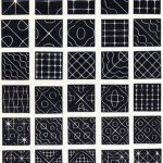
Signs of the times Examples of the geoglyphs discovered in Asia – a swastika-like design and a dissected square. Experts are exploring what the works tell us about the culture that made them
Dating from as far back as approximately 3,000 years ago, the 50 geoglyphs are thought to be the oldest examples of such art in the world. Almost all consist of dozens of large earthen mounds formed into geometric patterns including giant circles, crosses and squares dissected by diagonal lines. The most complex geoglyph is made up of 101 individual mounds, while the most unusual, comprised of linear earthworks rather than mounds, is in the shape of a swastika-type design – a solar symbol in ancient times.
The scale of the artworks is staggering. Each mound measures between 10 and 12m in diameter and may originally have stood at 2 or 3m high. The largest resulting design is a huge cross, 436m across, consisting of 39 individual earthen mounds.
The method by which the sites were found is also remarkable: scholars surveyed vast areas of land using Google Earth, an online virtual globe that allows users to explore high-resolution satellite images of the planet’s terrain. Archaeologists from Vilnius University in Lithuania and Kostanay University in Kazakhstan are now joining forces with amateur archaeologists to use the software to systematically search an area of hundreds of thousands of square miles over the coming years. It is thought that dozens, possibly hundreds, of further examples await discovery in other areas of the steppes.
The experts also hope to crack the riddle of who built the geoglyphs and the reasons that they did so. Until now, it was thought that the only major monuments built by the Iron Age nomadic peoples who inhabited the region’s vast grass-covered plains were the mounds in which they buried their dead. However, the size of the newly discovered geoglyphs suggests both that they had other uses and that their creators were more socially and organisationally advanced than previously thought.
“Until now, we had little indication of how socially organised these prehistoric steppeland nomads were”
All of the geoglyphs found so far in the current project were built within an area of 70,000 square miles. Archaeologists suspect that their specific locations suggest that the monuments would have had religious, economic and political significance: almost all are situated on high ground between river systems, indicating that they may have represented the points at which adjacent tribal or clan territories or pasture lands met.
Archaeologist Dr Giedre Motuzaite Matuzeviciute of Vilnius University, one of the leaders of the survey project, told BBC History Magazine: “Until now, we had little indication of how socially organised the prehistoric nomads of this steppeland were. Now, for the first time, we are seeing archaeological evidence that suggests they were able to bring together and organise substantial numbers of people to create very large-scale communal monuments.” (Source : BBC History)
You May Want to See :
-
 8 Legal Drugs Around The World
-
 Giant Magellan Telescope (GMT)
-
 How Google Cardboard works
-
 The Nanocomputers are Coming
-
 How eBay For Charity Works
-
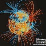 Polar flip coming soon?
-
 The Canon EOS M System
-
 How Music Help to Shape Modern Science
-
 What is Monochromatic Light ?
-
 How to cut metal and diamond using laser
-
 ASUS ROG SWIFT PG278Q
-
 Dark Matter Estimates For Milky Way Slashed
-
 Volocopter, an electrically powered VTOL aircraft
-
 Discover the Technology of 3D Printing
-
 Nine Technologies That Apple Disrupted at WWDC
-
 How Laser Improving Optical Microscopes Sharpness
-
 Ghost Recon: Wildlands
-
 The key to early 5G investigation
-
 5 Tips To Make you Live Longer Based on Research
-
 What do you need to access 4G ?
-
 Risks of Using Public Wifi


